 |
| From the Umpqua National Forest we trekked on over to the rugged and beautiful Oregon coastline. |
 |
| We made our first camp on the Oregon coast at Sunset Bay, which is about 10 minutes South of Coos Bay. |
 |
| Our trusty UAV settled in at Sunset Bay. Everywhere you turn it is a vibrant green. Each morning we were greeted with a misty rain, reminding us that we are in the Pacific NW rain forest. |
 |
| One of the many beautiful vistas afforded within the Sunset Bay State Park. |
 |
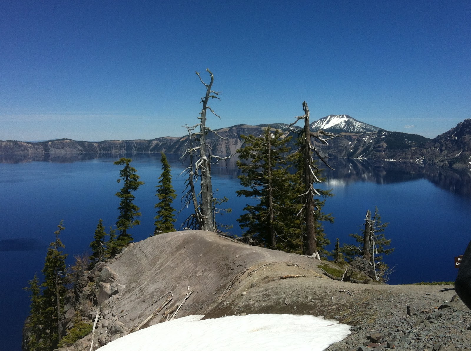
| Pictures just do not do the views justice. You cannot get the sound of the incessant crashing of the Pacific waves on the rocks in a picture! |
 |
| I couldn't have asked for a better Father's Day memory than being here in the botanical gardens in Sunset Bay State Park with my two beautiful red-headed roses! I'm blessed way beyond what I deserve! |
 |
| Another view of the botanical gardens in Sunset Bay. |
 |
| The girls spotted these guys swimming all around in the botanical garden ponds. The girls said they looked like little mini-dragons similar to their favorite dragon "Toothless" in the animated movie; "How to Tame Your Pet Dragon". We later learned that these guys are called Rough-skinned Newts and they are particularly poisonous. They produce a tetrodoxin in their skin as a defense against predation. It is supposedly only dangerous if you ingest it. However, some people have reported skin irritations after handling them. It is recommended that you wash your hands thoroughly after handling them. |
 |
| The girls pose outside the interpretative center at Sunset Bay with a pair of jaw bones of a gray whale. These bones where recovered front the Sunset Bay beach in 2007. |
 |
| Inside the interpretative center the girls learn that the North American Mountain Lion, also commonly referred to as panther or cougar, is also a resident of these parts of the country. Hailey shared all that she learned about these creatures from our time at Big Bend National Park in Texas, where the Mountain Lion is common. |
 |
| We learned that Oregon State Parks have a Junior Ranger Program much like the National Park Service. So, naturally, Hailey took part! Here she studies what she found on a Ranger led scavenger hunt. |
 |
| Hailey shows off her Oregon Junior Ranger badge that she earned at Sunset Bay. |
 |
| Arago Cove in Sunset Bay State Park. We went down here one evening to investigate the intertidal pools during minus tide. We saw two gray whales in the cove spouting and flipping onto their sides. I could not get a good shot of them with my iPhone, unfortunately. |
 |
| It turns out that the girls favorite pastime here on the Pacific Northwest coast is exploring for aquatic life in the tide pools at minus tide. This picture was taken in Arago Point Cove. |
 |
| Heidi shows me a green sea anemone that she found at Arago Point Cove. We touched them and they stuck to our fingers. We could sure tell that is how they capture their unsuspecting prey. |
 |
| It was the season for new life and new beginnings and we saw plenty of harbor seals, and sea lions up on the rocks. However, as this trail sign indicates, not too close. |
 |
| We took a trip up the road to Coos Bay. We had no cell phone or wifi down in Sunset Bay, so in order to call our respective Dads on Father's Day, we had to drive into town to make a call. And while here, we took in some of the sights of a hard working fishing town. According to Oregon historical names, Coos is the name given the Native Americans who lived in their area. The Lewis and Clark expedition of 1804 to 1807 made mention of them as Cook-Koo-Oose. |
 |
| The girls pose in front of the tugboat Koos. The original Koos was used as a travel boat by the Simpson family to travel to their Shore Acres family estate from Coos Bay. Shore Acres would later become Sunset Bay State Park. The Koos would later be converted into a tugboat. |
 |
| As we traveled North up the coast towards Florence, we stopped at the Oregon National Dunes Recreation Area. It is locate approximately 40 miles North from the Coos River in North Bend. The dunes adjoin the Honeyman State Park. We stopped here in a day use area and had lunch. The dunes are a unique area of windswept dunes that are the largest expanse of coastal dunes in North America. Some dunes tower approximately 500 feet tall! The dunes stretch for over 50 miles along the coast. The science fiction writer Frank Herbert was inspired to write his novel "Dune" based upon his research of the sand dunes here. |
.
 |
| We also stopped at the Sea Lion caves. This is a shot looking North over the jagged cliffs. The roar of the waves crashing here was very impressive. |
 |
| We took a 208 foot elevator ride down into the sea lion caves. It was "other worldly"! The Sea Lion Caves is one of the great sea grottos of the world, comparable to the famed Blue Grotto in the Mediterranean. This cave system is at sea level and the ocean continually washes into this main cavern, which has an area of about 2 acres and has a vaulted dome about 125 feet high. This portion of the grotto has become the only mainland wintering and rookery home of the Stellar Sea Lion and California Sea Lion. If you look closely, you can see them in this picture. It was very noisy in here with the constant waves crashing and the barking of the sea lions! |
 |
| We stayed just North of this town in Beverly Beach State Park. Newport truly is one of the few honest to goodness fishing towns in the country, where fishing is the main way people make a living and the associated industries that support fishing. We went down to the bay waterfront and watched the fishing vessels coming in and unloading at the seafood companies. |
 |
| Here we are...all cozy at Beverly Beach State Park. We were fortunate enough to get placed in a park host site that was not being used. It was nice and big and it had full hook ups. |
 |
| Spencer Creek at Beverly Beach State Park ran right behind our campsite and spills out onto Beverly Beach and into the ocean. You can see some occupied campsites near the beach in the upper corner of this picture. |
 |
| Hailey makes a friend at Beverly Beach. Her name is Hope and she is from Oregon. They soon became inseparable during our stay here. Hope was also into the Oregon Jr. Ranger program, so Hailey and Hope immediately had something in common! |
 |
| Hailey inside the Beverly Beach interpretive center. Here she poses with a skull of a Gray Whale that beached here on Beverly Beach State Park. |
 |
| The gals pose next to Spencer Creek, where it pours out into the Pacific Ocean. |
 |
| We took a "field trip" to Yaquina Bay Lighthouse near Newport. It was built in 1871. The lighthouse is still a USCG aid to navigation and the grounds are managed by the Bureau of Land Management. Oh, and they have a Jr. Ranger Program. Yep, Hailey signed up. |
 |
| Hailey goes about completing her Jr. Ranger booklet assignments and poses with the lighthouse keeper's daughter in full period costume. She describes what life was like in the late 1800's and early 1900's for a family of a lighthouse keeper, including a story recorded in the lighthouse keeper's log about his horse getting blown over the cliff and into the ocean. |
 |
| Hailey climbs the lighthouse stairs and at the top she poses with the lighthouse keeper himself. |
 |
| Hailey in the lighthouse "Oil Room" with 100 gallon tanks. We learned that when lighthouses were first constructed the lights were lit by whale oil. However, whale oil was very expensive and this soon led to the search for a less expensive alternative. Any guesses? Answer: Oil from pig fat! How's that you ask?! You take all that fat from, frying bacon, for example, and collect it and let it set at room temperature for a year. A thin layer of oil will form on the top. It was this oil that was skimmed off, placed in containers and shipped out to lighthouses and used to light the lighthouse lights. Each light house would have an oil room that would house several 100 gallon containers that the lighthouse keeper would draw from to take to the top of the lighthouse to feed the wick. Each lighthouse could store about 900 gallons, which would last about 11 months. At one time, there were over 700 lighthouse in use, each using pig oil. Now that's a lot of bacon! |
 |
| Hailey shows of here Yaquina Lighthouse Jr. Ranger badge. |
 |
| Heidi and I get up early in the morning to catch the minus tide at Beverly Beach State Park, in order to go searching for sand dollars. |
 |
| Well, we did not find any sand dollars but, we found a bunch of cool sea stars. |

 |
| We got a late start out of Beverly Beach because we had blown fuses in our motor home and needed to get them fixed, in order to have lights working, while we towed our tow vehicle. The great folks at Allstart Automotive and Electric helped me isolate the appropriate fuses and replace them. If you ever find you are in need of automotive or electric repairs in the Newport area, I highly recommend them! Even with our late start, we had time to take a short tour of the Tillamook Cheese Factory in Tillamook, Oregon. I did not realize how big dairy was in this area. We learned that it takes 1.7 million pounds of milk to make 167,000 pounds of cheese. Tillamook Cheese is supplied with the necessary milk from 120 different local dairies. Fortunately for us...free samples! |
 |
| Here is the area where we ended up stopping for awhile...the place where the Louis and Clark Expedition encountered the Pacific Ocean. We stayed at Fort Stevens State Park, which used to be an Army Post up until 1947. |
 |
| In Astoria, we got our dose of nautical information! We learned that there are over 2,000 recorded shipwrecks at the "bar" of the Columbia river, where it encounters the Pacific Ocean. It is one of the most treachous places to navigate in the world. |
 |
| Hailey admires the pitch of a Coast Guard Motor Life Boat, which demonstrates what a daunting task the USCG has in conducting at sea rescues at the sometimes violent "bar" of the Columbia River. We learned that the USCG launches missions some 300 times out of the year. The USCG has their Motor Life Boat "schoolhouse" here in Astoria. Also, of note, their is only about 120 days of sunshine in this part of the country. Opposite of what our Florida, sunshine State gals are used to! |
 |
| What is this?! Well, it is a picture of the Peter Iredale, a British Merchant ship that went aground near the bar of the Columbia in 1906. It went aground in what is now Ft. Stevens State Park. |
 |
Here is Heidi with the Peter Iredale, as it looks today on the beach at Ft. Stevens State Park. Did you know that Ft. Stevens was attacked by the Japanese Imperial Navy during WWII? I didn't! The bombardment of Fort Stevens occurred in June 1942 by a Japanese submarine. No lives were lost in the attack. However, the attack helped to create the "West Coast Invasion scare". Rolls of barbed wire were strung from Point Adams southward and the wire would entangle the wreck of the Iredale throughout the war, as she became a part of the West coast defensive line. The attack on Ft Stevens was the only time during WWII that a Continental US military installation was attacked by the Axis Powers. |
 |
| The girls in front of a replica of the original Ft. Clatsop, which stood right here and is where Lewis & Clark wintered and re-supplied before making the long arduous trek back to "The States", as this area was just wild territory and not yet considered a part of the United States. Some of the things we learned was that Meriwether Lewis was personal secretary to President Thomas Jefferson, whom selected Lewis to organize and lead an expedition into the new Louisiana Purchase, acquired from France. Lewis, a former US Army Captain and infantry officer, asked his former commanding officer, William Clark, who at the time had left the Army for a civilian business venture, to join him as co-leader and promised him a reinstatement to his former rank of Captain. Lewis drew up the order and President Jefferson signed it and sent it to the War Department to be published. It was months later, just as the Exepedition was to depart from St. Louis that Lewis and Clark received the commissioning order from the War Dept. and.... the order read; "...Reinstatment to the rank of...First Lieutenant.." This was a great embarrassment to Lewis, a Virginia born gentleman, who gave his word to his former commanding officer that he be reinstated to his former rank of Captain. It seemed that the Generals at the War Department could not understand why it took two Captains to lead a small contingent of men and that having two Captains would only lead to trouble. So, they took it upon themselves to ensure only one superior officer was designated. Well, Lewis & Clark told none of the men of the expedition about the order and Lewis bestowed a "field commission" of Captain in the Corps of Discovery upon Clark. If you ever read any documents signed by Clark and compare the signature block to Lewis, you can clearly tell that Clark was keenly aware of his commissions limitations because he always signed it with "Corps of Discovery" following his rank and Lewis signed his with 1st Infantry following his rank. Clark knew his field commission only applied to the Corps of Discovery and not within the US Army, as a whole. However, none of the men in his trust knew this nuance. Ah, nothing much has changed in the military! |
 |
| Heidi has a seat in a replica of a dugout canoe, much like the one's the natives showed Lewis & Clark how to construct from a single log using controlled fire to hollow it out. This one is near Netul Landing, the spot Lewis & Clark landed in search of a spot to winter, about a half-mile from what would be come Ft Clatsop. Then name Clatsop was chosen to honor the local natives of the same name, who helped the expedition survive the winter. |
 |
| I had to lead by example to get Heidi to join the effort of Jr. Rangering! Here Heidi and I take the Ft. Clatsop Jr. Ranger oath, after we successfully complete the age 13+ Jr. Ranger booklet assignments. Depending upon how much you completed in the book determined what "rank" you attained..."Sergeant, "Captain", "President". Heidi and I got our badge and attained the rank of "Captain". I put the "Captain" rank badge we earned on the back of my drivers chair in our motorhome. :) |
 |
| Like Mother like Daughters! Entrepreneurs each! Heidi and Hailey made homemade fudge and setup selling it in the campground in Ft. Stevens. They aim to help "finance" their education and this trip by selling fudge where ever we camp. It was fun to watch. They actually made money doing this! They had quite the "system" going. Hailey would be out front selling using "samples" to hook the customers. Heidi would be inside the motorhome with the "supply" of fudge in the fridge. Each would have a walkie talkie. Hailey would call in to Heidi to bring out the appropriate flavor with a "WHOO, HOO" WE GOTTA SALE FOR ONE MARSHMELLOW FUDGE!" |
 |
| Eager customers! I also think they thought the girls were cute! Easy boys! I got my eyes on ya both! These guy went back and spread the news. The best customers turned out to be the "Dads"! |
 |
| It's off to Seattle area! We plan to spend at least a couple of weeks in that area. The girls are excited to see another big city and explore the Public Market, where they "throw fish" around! :) |


